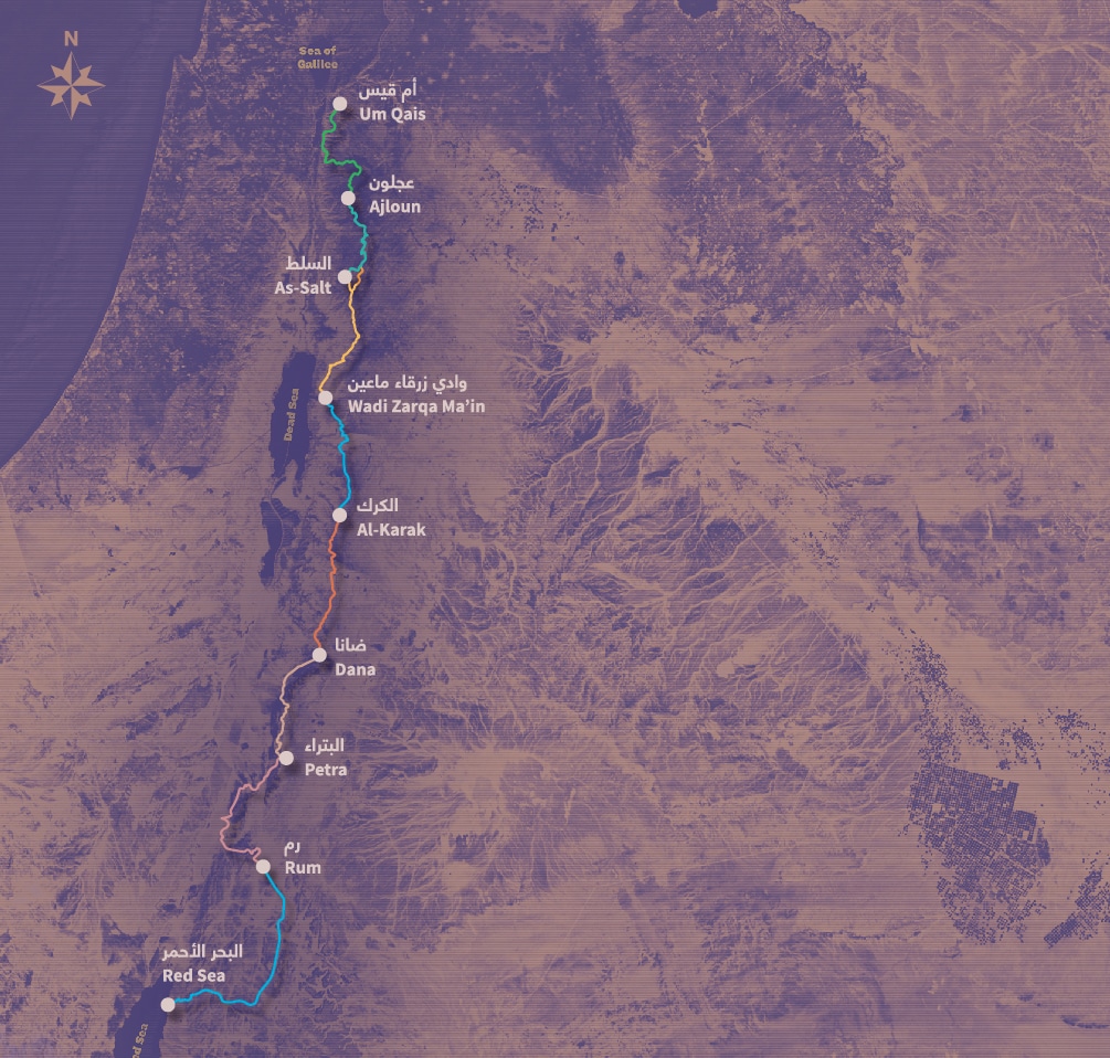
يُعد درب الأردن مسارًا طويلًا للمشي يمتد لمسافة 675 كيلومترًا، ويعبر كامل أراضي المملكة من أم قيس في أقصى الشمال وصولًا إلى العقبة على ساحل البحر الأحمر في الجنوب.
يمتد هذا المسار على مدار نحو 35 يومًا من المشي المتواصل، ويمر عبر أكثر من 75 قرية وبلدة، حيث يربط بين تنوّع الطبيعة والثقافات والتاريخ في الأردن ضمن رحلة متكاملة. فهو ليس مجرد عبور جغرافي، بل تجربة تنقلك عبر الزمن أيضًا.
من التلال الخضراء المتموجة والمكسوّة بالغابات في الشمال، إلى الصحارى الرملية المهيبة في الجنوب، يكشف هذا المسار عن التنوع الجغرافي الاستثنائي في الأردن. وعلى امتداد الطريق، يعبر المتنزهون أودية وعرة تُطل على وادي الأردن، وسهولًا زراعية خصبة، وطرق قوافل تاريخية، وحصونًا صليبية، ومدنًا نبطية منحوتة في الصخر، إضافة إلى مساحات شاسعة من الصحراء، قبل أن ينتهي بهم المطاف عند المياه الصافية للبحر الأحمر.
المشي على درب الأردن ليس مجرد مغامرة في الهواء الطلق، بل هو تجربة غامرة في الثقافة المحلية. يتيح المسار للمتنزهين فرصة التعرّف على المجتمعات المحلية عن قرب، من خلال الإقامة في بيوت الضيافة العائلية، وتذوّق المأكولات التقليدية، واختبار كرم الضيافة الذي يشتهر به الأردن. كما تمثّل الرحلة عبورًا عبر آلاف السنين من الحضارات الإنسانية، بدءًا من المواقع ما قبل التاريخ، مرورًا بالمدن الرومانية، وصولًا إلى الأديرة البيزنطية والمواقع الإسلامية التراثية.
The Jordan Trail is a newly established trail, and is not marked. It is therefore our strong recommendation that you hire a local guide for your safety as many sections are remote with limited water sources and at times no connectivity.
Seperate SEO fact from fiction & stop wasting your time on SEO strategies that dont work.
The Jordan Trail is a newly established trail, and is not marked. It is therefore our strong recommendation that you hire a local guide for your safety as many sections are remote with limited water sources and at times no connectivity.
By downloading these maps/GPX you take full responsibility for their use and accuracy; Jordan Trail Association does not warrant the accuracy or completeness of the information, materials or the reliability of any maps as they provided AS IS without warranty of any kind, either express or implied, including but not limited to, fitness for a particular purpose, or non-infringement ;You acknowledge that any reliance on any such maps, shall be at your sole risk and responsibility as Hiking, backpacking, and other outdoor activities all have potential hazards involving risk of injury or death. Outdoor activities have inherent risks and you should ensure you have the skill level and abilities suitable for the activities in Jordan to partake in them and to take all precaution measures. Check the data on Google Earth or other Apps or Programs before using them. The Jordan Trail Association shall not be held responsible for any incidents that may occur during your participation in any activity and/or by using any of the maps/GPX.
The Jordan Trail is a newly established trail, and is not marked. It is therefore our strong recommendation that you hire a local guide for your safety as many sections are remote with limited water sources and at times no connectivity.
Seperate SEO fact from fiction & stop wasting your time on SEO strategies that dont work.