0
0 items
No products in the cart.

القسم 804: وادي رم إلى وادي ورقة

  • مسارات المشي في المنطقة

  • اليوم الرابع: قرية رم إلى وادي ورقة

  • المسافة: 20.5 كم

  • الوقت اللازم للمسير: 6-8 ساعات

  • التحدي البدني: صعب

  • صعوبة المسار: سهل

  • اجمالي الصعوبة: متوسط

  • تعليم المسار: لا

لتحميل مسار GPS، اضغط هنا.  

The Jordan Trail is a newly established trail, and is not marked. It is therefore our strong recommendation that you hire a local guide for your safety as many sections are remote with limited water sources and at times no connectivity.
AGREE
close-link

أنقر هنا

The Jordan Trail is a newly established trail, and is not marked. It is therefore our strong recommendation that you hire a local guide for your safety as many sections are remote with limited water sources and at times no connectivity.
By downloading these maps/GPX you take full responsibility for their use and accuracy; Jordan Trail Association does not warrant the accuracy or completeness of the information, materials or the reliability of any maps as they provided AS IS without warranty of any kind, either express or implied, including but not limited to, fitness for a particular purpose, or non-infringement ;You acknowledge that any reliance on any such maps, shall be at your sole risk and responsibility as Hiking, backpacking, and other outdoor activities all have potential hazards involving risk of injury or death. Outdoor activities have inherent risks and you should ensure you have the skill level and abilities suitable for the activities in Jordan to partake in them and to take all precaution measures.  Check the data on Google Earth or other Apps or Programs before using them.  The Jordan Trail Association shall not be held responsible for any incidents that may occur during your participation in any activity and/or by using any of the maps/GPX.
AGREE
close-link
لتحميل الخريطة
أرقام مهمة

الشرطة السياحية:

الخط الساخن: 117777
واتساب: +962770992690

*في حال التواصل مع شرطة السياحة في حالة طارئة، يُرجى تحديد أنك تسير على درب الأردن، وذكر جنسيتك، موقعك الحالي، واسم ورقم الخريطة.

مكتب جمعية درب الأردن: +962 6 461 0999

(Working Hours: 9:00 a.m. to 5:00 p.m., Sunday- Thursday

معلومات عامة

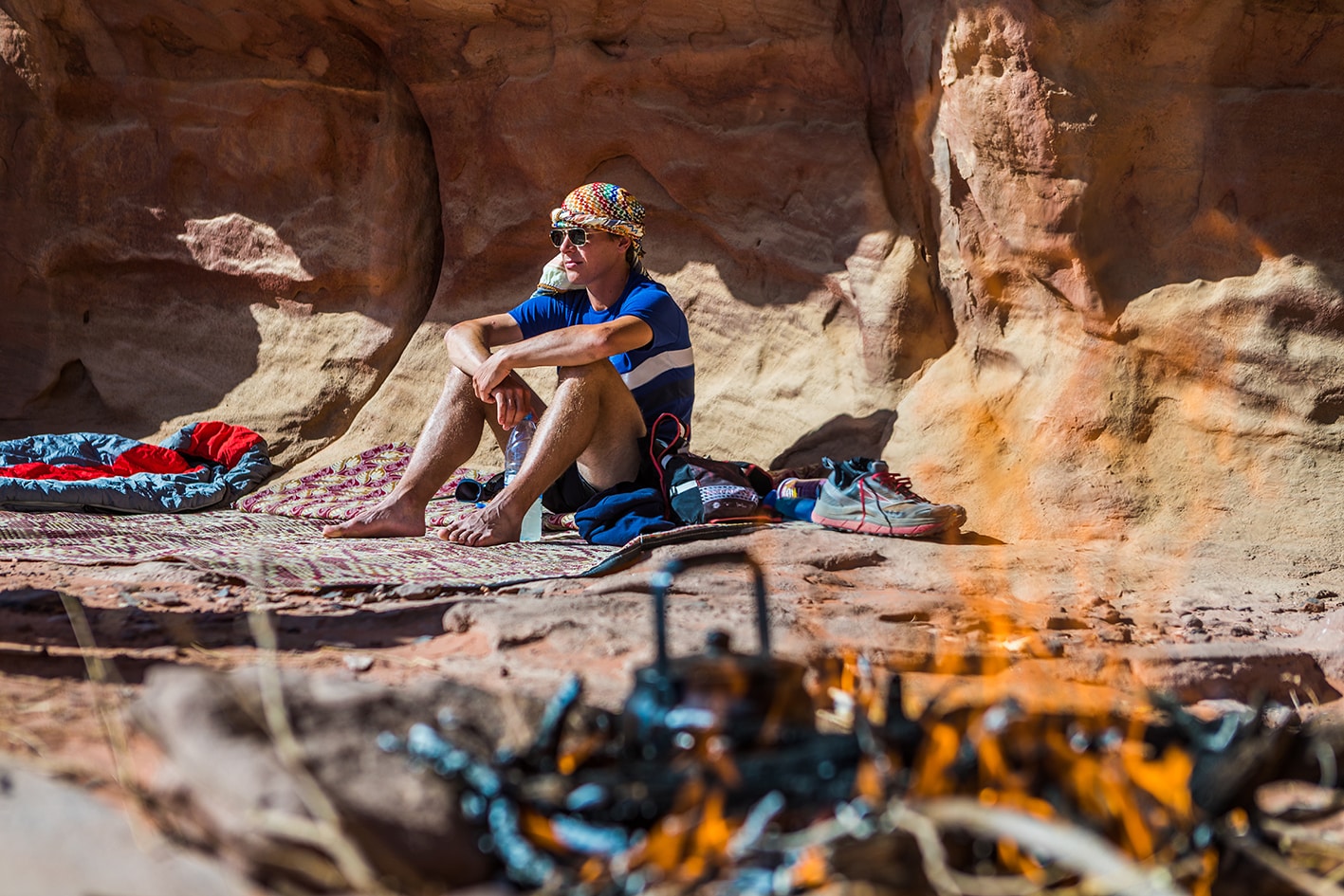
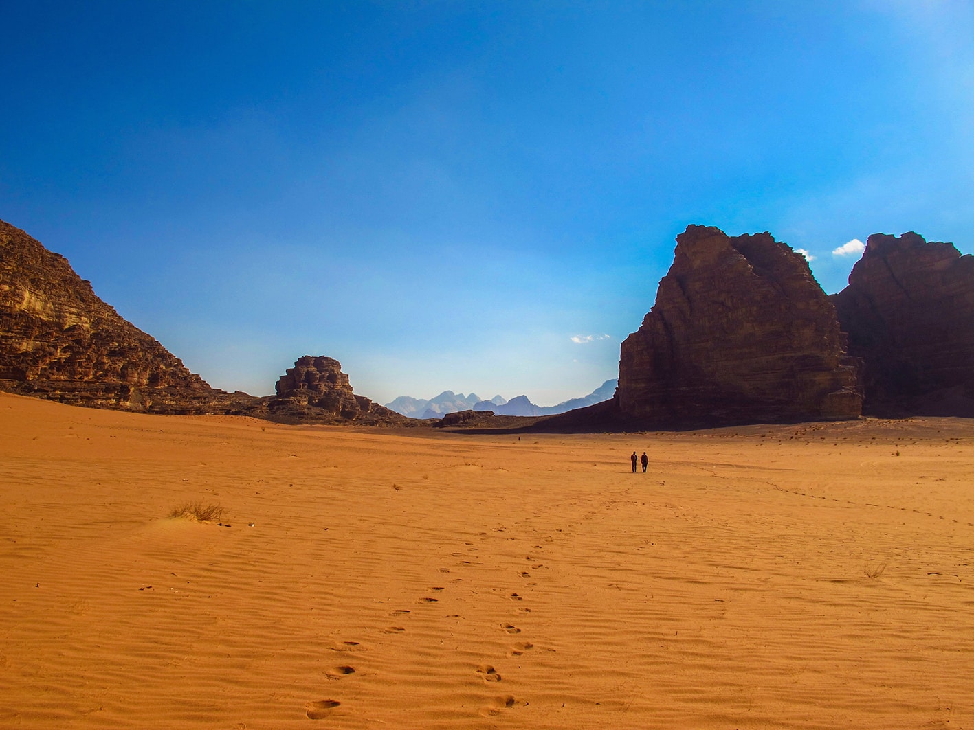
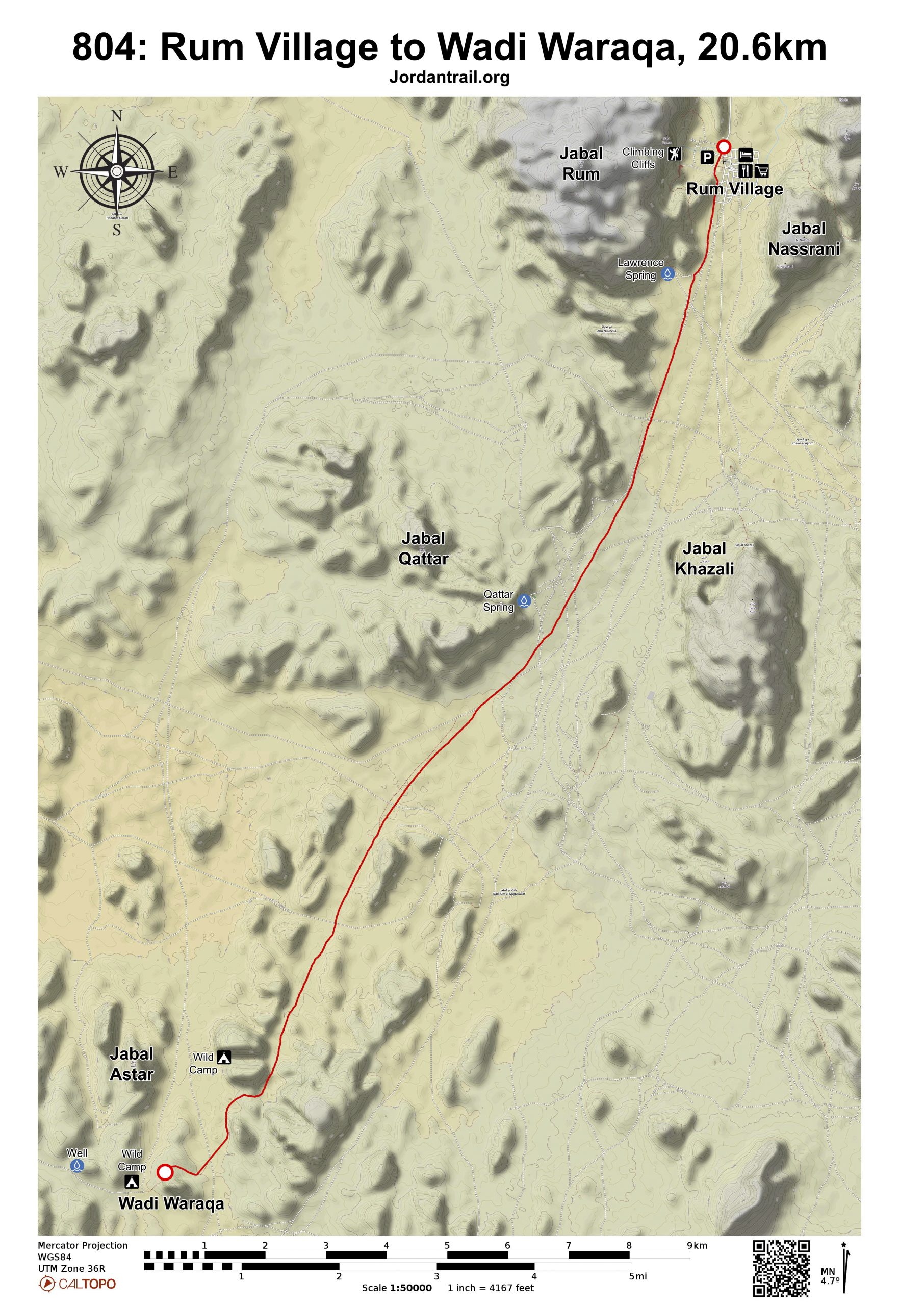
من بيت الاستراحة في وادي رم، الواقع في الطرف الشمالي من قرية رم، انطلق جنوباً عبر الشارع نفسه مباشرة حتى تصل إلى نهاية القرية. واصل السير على طرق سيارات الدفع الرباعي، مارّاً بالقرب من خيام البدو، ثم مرّ بـ عين لورنس عند مسافة 2.7 كم. تمر في هذه المنطقة عدة مسارات لسيارات الدفع الرباعي، وقد يكون من الأفضل أحياناً استخدامها، بينما في أوقات أخرى قد يكون السير على الأرض المجاورة أكثر صلابة وسرعة. استمر في الاتجاه نفسه نحو الجنوب على زاوية تقارب 195 درجة، لتصل إلى عين قطر التي يمكن تمييزها ببقعة خضراء عند سفح الجبل على يمينك على بعد 9 كم. من العين، اتجه إلى يمين الجبال الرملية التي تراها أمامك مباشرة، واصعد فوق منطقة رملية صغيرة لتدخل وادياً أضيق يوفّر المزيد من الظل.

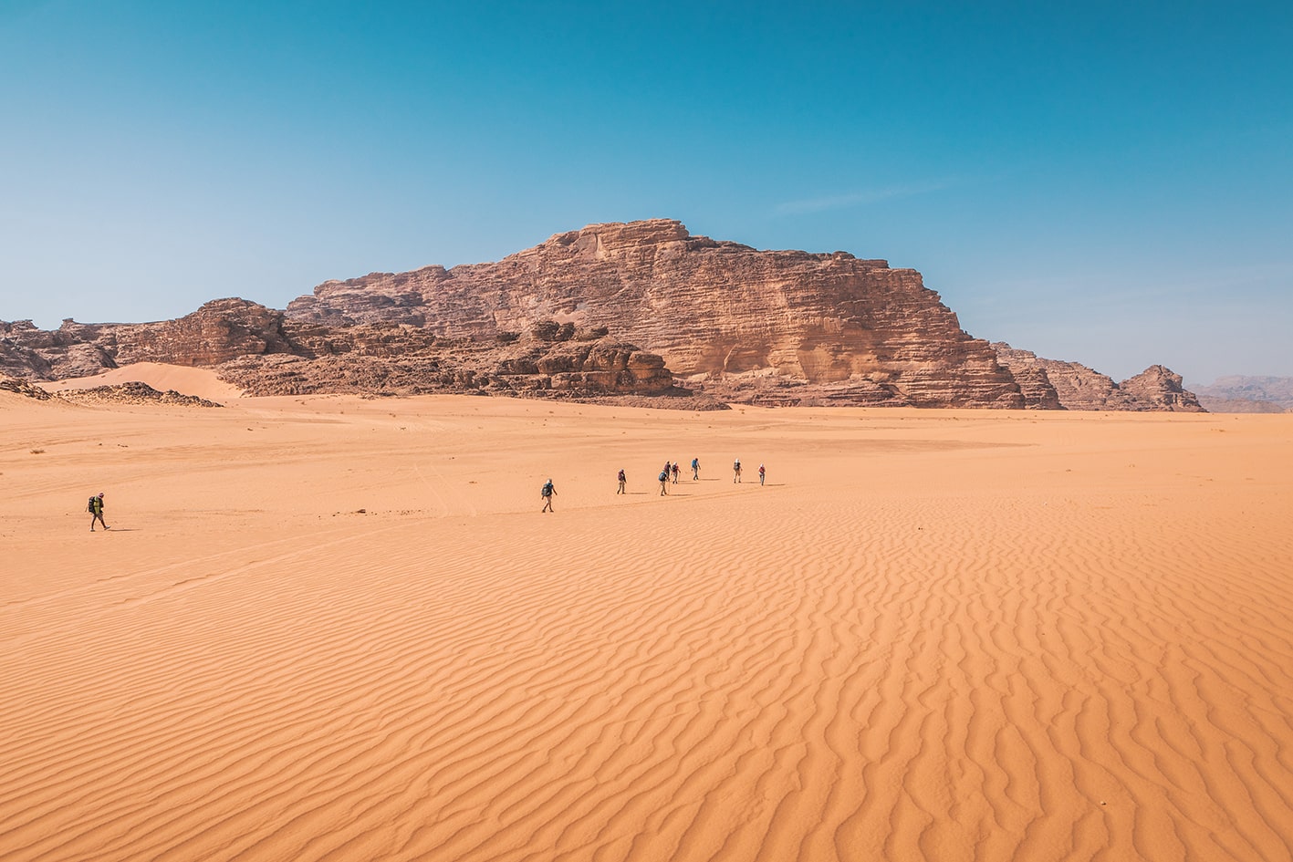
تابع السير مباشرة حتى تعبر طريقاً أوضح مخصصاً لسيارات الدفع الرباعي، ثم ارتقِ قليلاً في وادٍ رملي أكثر نعومة يضيق عند مرورك بجبال القدير. راقب جهاز الـGPS لتنعطف غرباً (يميناً) عبر رمال رخوة جداً حتى تصل إلى وادٍ واسع. اعبر الوادي من الجنوب لجبل عنترة، حيث تبدأ الجبال الرملية بالاختفاء، ويصبح مدخل وادي ورقة واضحاً من جهة الغرب. هنا تقع النقطة الجنوبية القصوى لـ مسار الأردن، ومنها ستتجه غرباً للوصول إلى البحر الأحمر. في هذه المرحلة، تتلاشى الرمال تدريجياً لتحل محلها أسطح من الجرانيت والكوارتز والحصى.

وسائل النقل
  • توجد حافلات عامة وسيارات أجرة تعمل بين العقبة ووادي رم.
  • يمكن القدوم بسيارة أجرة من البتراء.
  • بعد قرية رم، يتوفر فقط النقل بسيارات الدفع الرباعي أو شاحنات البيك أب الخاصة على طول مسار اليوم.
جهات الاتصال المحلية / أماكن الإقامة
  • التخييم البري, سليمان الزلابية, 962795902127+, ختم سجل الدرب وادي رم, وادي ورقة, والمخيم الأخير
  • التخييم البري, هاجس زلابية, 962777446702+
  • التخييم البري, عبدالله مراد زوايدة, 962795088157+
أهم المعالم التي يمكن مشاهدتها
  • نبعة لورنس
  • نبعة قطّار
  • القدر
  • جبال البحر الأحمر
  • كهف عنترة
الطعام والماء

الطعام:

  • الوجبات والماء متوفرة في الخيام البدوية في وادي رم.

الماء:

  • فقط في الخيام البدوية.
  • ممكن الحصول عليهما عند عين لورنس وعين القَطَر، لكن يُستحسن التأكيد في قرية رم.
النصائح والسلامة العامة

النصائح:

  • المسار رملي للغاية؛ كُن مستعداً ذهنياً لذلك!
  • من الأفضل تقصير المسافة عبر السير بخطوط مستقيمة.
  • يصعب شرح الاتجاهات، لذا من الجيد امتلاك جهاز GPS أو دليل أو مهارات ممتازة في قراءة الخرائط واستخدام البوصلة.
  • انتبه للمسافة التي تقطعها باستخدام جهاز GPS أو عبر متابعة وتيرة سيرك المعروفة مع مرور الوقت.
  • المنطقة بعد قرية رم نائية وتوجد بها مصادر قليلة للمياه أو المؤن حتى الوصول إلى البحر الأحمر.استعد بخطة جيدة للمياه وكمية كافية من الطعام لآخر ثلاثة أيام.

وسائل النقل:

  • توجد حافلات عامة وسيارات أجرة تعمل بين العقبة ووادي رم.
  • يمكن القدوم بسيارة أجرة من البتراء.
  • النقل متاح فقط عبر سيارات الجيب أو البيك أب في مرحلة اليوم التي تتجاوز قرية رم.

تغطية الهاتف المحمول: لا توجد تغطية بعد الانعطاف من قرية رم. إذا كنت تخطط لترتيب شيء مثل الإقامة أو النقل المحلي، تأكد من القيام بذلك مسبقًا وأن تكون واضحًا بشأن الموقع والوقت.

The Jordan Trail is a newly established trail, and is not marked. It is therefore our strong recommendation that you hire a local guide for your safety as many sections are remote with limited water sources and at times no connectivity.
AGREE
close-link

The Jordan Trail is a newly established trail, and is not marked. It is therefore our strong recommendation that you hire a local guide for your safety as many sections are remote with limited water sources and at times no connectivity.
By downloading these maps/GPX you take full responsibility for their use and accuracy; Jordan Trail Association does not warrant the accuracy or completeness of the information, materials or the reliability of any maps as they provided AS IS without warranty of any kind, either express or implied, including but not limited to, fitness for a particular purpose, or non-infringement ;You acknowledge that any reliance on any such maps, shall be at your sole risk and responsibility as Hiking, backpacking, and other outdoor activities all have potential hazards involving risk of injury or death. Outdoor activities have inherent risks and you should ensure you have the skill level and abilities suitable for the activities in Jordan to partake in them and to take all precaution measures.  Check the data on Google Earth or other Apps or Programs before using them.  The Jordan Trail Association shall not be held responsible for any incidents that may occur during your participation in any activity and/or by using any of the maps/GPX.
AGREE
close-link