0
0 items
No products in the cart.
0
0 items
No products in the cart.

REGION 8: RUM TO RED SEA

  • Details

    Heading south down Wadi Rum, the trail traverses dramatic sandstone mountains and “godlike" landscape as described by T.E. Lawrence, passing beneath the cliffs of Jebel Rum and Um Ishrin. Ancient shepherd paths guide hikers westward across colored rock formations and granite peaks marked by basalt intrusions until, at the final pass, the turquoise waters of the Red Sea and the Gulf of Aqaba come into view, with the Sinai Mountains visible across the horizon. The journey ends at the shores of Aqaba, where desert mountains meet coral seas.

    6 days Distance: 112 km Ascent: 1,824 m Descent: 2,755 m Max Elevation: 1,042 m Min Elevation: 0 m

  • Main sites in the region:

  • Wadi Rum (World Heritage site)

  • Wadi Rum Bedouin village

  • Lawrence’s Spring and the Nabataean Temple

  • Bedouin encampments

  • Village of Titen

  • Red Sea

To download the GPS track,  Click here.. 

Click Icon

The Jordan Trail is a newly established trail, and is not marked. It is therefore our strong recommendation that you hire a local guide for your safety as many sections are remote with limited water sources and at times no connectivity.
By downloading these maps/GPX you take full responsibility for their use and accuracy; Jordan Trail Association does not warrant the accuracy or completeness of the information, materials or the reliability of any maps as they provided AS IS without warranty of any kind, either express or implied, including but not limited to, fitness for a particular purpose, or non-infringement ;You acknowledge that any reliance on any such maps, shall be at your sole risk and responsibility as Hiking, backpacking, and other outdoor activities all have potential hazards involving risk of injury or death. Outdoor activities have inherent risks and you should ensure you have the skill level and abilities suitable for the activities in Jordan to partake in them and to take all precaution measures.  Check the data on Google Earth or other Apps or Programs before using them.  The Jordan Trail Association shall not be held responsible for any incidents that may occur during your participation in any activity and/or by using any of the maps/GPX.
AGREE
close-link
to download the map

REGIONAL TRANSPORTATION

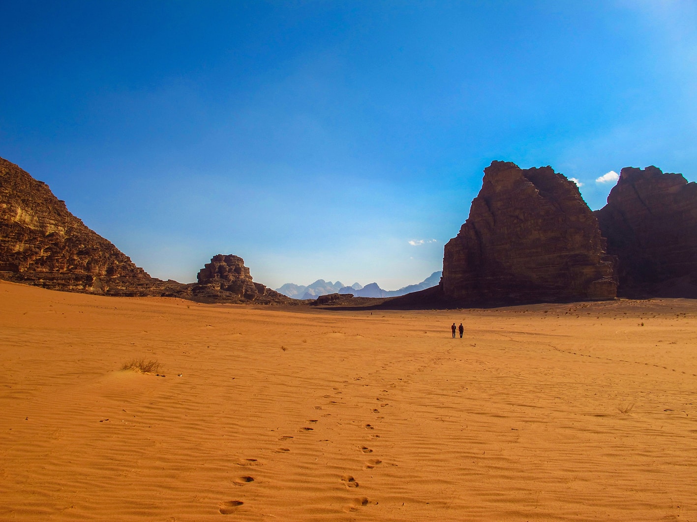
Aside from Wadi Rum and the city of Aqaba, this region is not reachable by public transit – to reach points along the trail you’ll have to drive or hire a taxi or, more likely, a Bedouin driver with a 4-wheel-drive vehicle.

For a major tourist destination, Wadi Rum is somewhat difficult to reach. If not driving, you’ll have to find one of the few daily buses that reach it or take a bus running along the desert highway and then walk or try to catch a taxi the rest of the way.

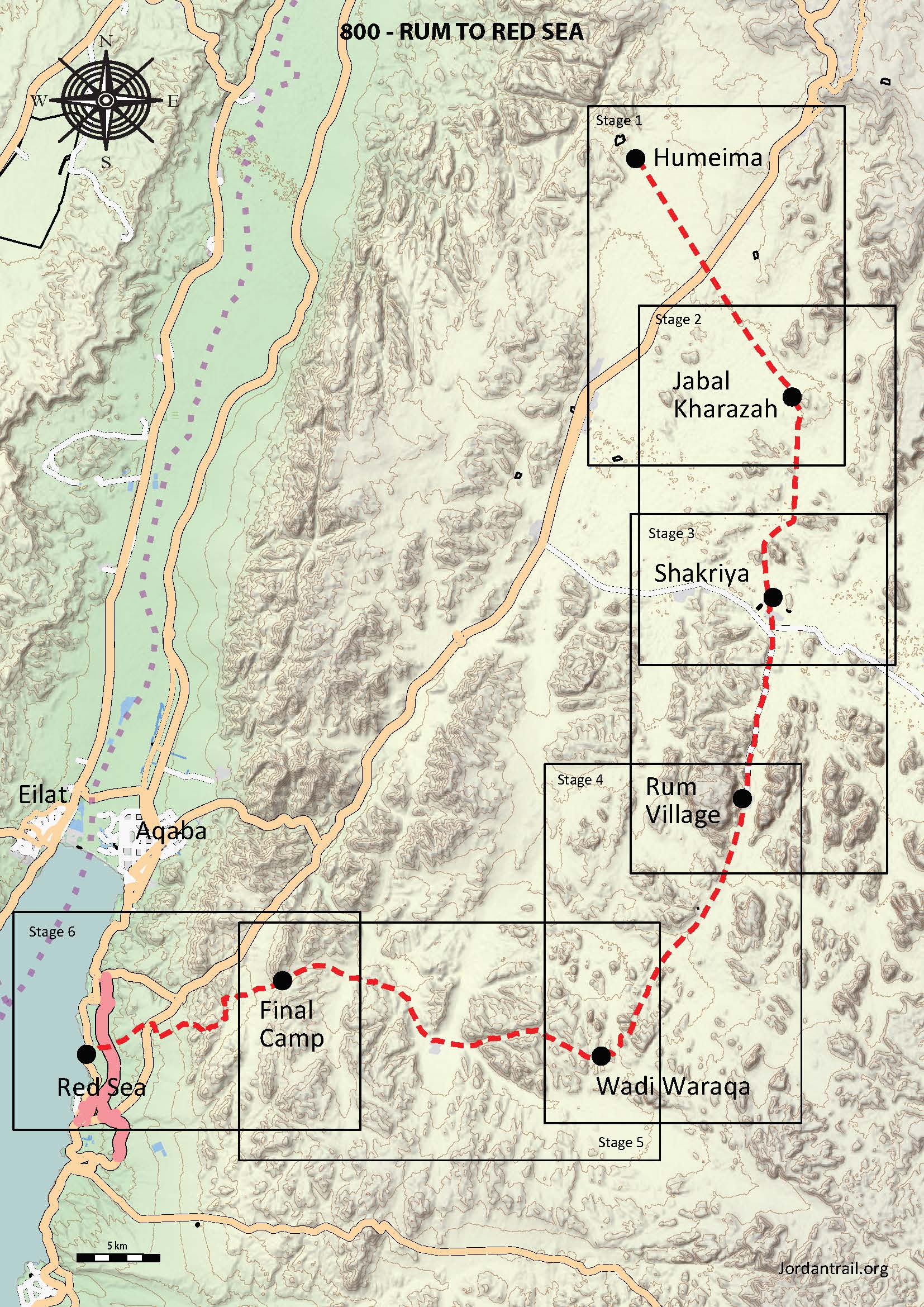
Rum Village, about 10km down a dead-end road past the Visitors’ Center, contains a few shops and the Rest House (a cheap restaurant and accommodation option); Jeep tours taking you to a desert camp will leave from the Visitors’ Center. Both points are on the Jordan Trail route.

As mentioned on Jordan Jubilee, the most exhaustive and updated resource for travelers, a daily tourist bus (arranged by hotels) runs in the early morning from Petra to Wadi Rum and then back again; and a once-a-week luxury JETT bus runs from Amman to Wadi Rum on Thursday night. Given the general unreliability of transportation in remote locations, travelers should not depend on these buses when leaving Wadi Rum but should instead plan to hire private transport.

If finding public transit all the way to Wadi Rum is too tricky, your other option is to take any public bus (not JETT or a tourist bus!) that runs along the Desert Highway (for example, between Amman and Aqaba) and disembark at Rashidiya Junction. From here, you must find private transportation or walk along the road heading east to Wadi Rum and Diseh.

Aqaba, being a major city, is easy to reach by bus from anywhere that has buses; and transportation within the city is easy and cheap through green local taxis.

There is no public bus leading to the southern terminus of the trail along the Red Sea shore; you’ll need a taxi from Aqaba for pick-up or drop-off.

For more information on transportation in Jordan, click here.

Accommodations

Aqaba is a large tourist town and has plenty of hotels. The wilds of Wadi Rum are also full of tourist camps, which usually operate by picking up visitors at the Visitors’ Center and taking them to camp via a scenic jeep ride. Self-supported hikers are still generally an unknown breed; but if you hike into one of these camps, you may be able to stay the night there if there is room or even pay for transport to another camp. In both Aqaba and Wadi Rum, of course, overnight options vary widely in terms of cost, level of luxury, and quality.


Rum Village also has the Rest House, a small restaurant which offers tent camping in its backyard for 2JD for using your own tent and 3JD for using one of theirs. This price includes a shower, which may or may not have hot water.


Unless you make a detour off-trail to stay in one of Wadi Rum’s tourist camps, there are no accommodations in this region – wild camping is the way to go.

The Jordan Trail is a newly established trail, and is not marked. It is therefore our strong recommendation that you hire a local guide for your safety as many sections are remote with limited water sources and at times no connectivity.
By downloading these maps/GPX you take full responsibility for their use and accuracy; Jordan Trail Association does not warrant the accuracy or completeness of the information, materials or the reliability of any maps as they provided AS IS without warranty of any kind, either express or implied, including but not limited to, fitness for a particular purpose, or non-infringement ;You acknowledge that any reliance on any such maps, shall be at your sole risk and responsibility as Hiking, backpacking, and other outdoor activities all have potential hazards involving risk of injury or death. Outdoor activities have inherent risks and you should ensure you have the skill level and abilities suitable for the activities in Jordan to partake in them and to take all precaution measures.  Check the data on Google Earth or other Apps or Programs before using them.  The Jordan Trail Association shall not be held responsible for any incidents that may occur during your participation in any activity and/or by using any of the maps/GPX.
AGREE
close-link
EN